
Profile Perfect Level 571 Answer
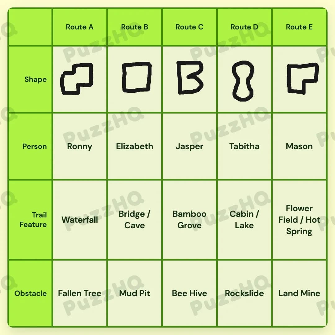
Every route from Route A through Route E is fully determined by matching each hiker to their destination, pairing key trail landmarks with their respective path hazards, and aligning each route shape to its mapped position.
| Trait | Route A | Route B | Route C | Route D | Route E |
|---|---|---|---|---|---|
| Shape | Shape1 | Shape2 | Shape3 | Shape4 | Shape5 |
| Person | Ronny | Elizabeth | Jasper | Tabitha | Mason |
| Trail Feature | Waterfall | Bridge / Cave | Bamboo Grove | Cabin / Lake | Flower Field / Hot Spring |
| Obstacle | Fallen Tree | Mud Pit | Bee Hive | Rockslide | Land Mine |
Building The Grid By Trait
Because the clues weave person identities directly into landmark discoveries, the strongest way to enter the puzzle is through the Person and Trail Feature rows. Once those two categories establish the layout of the five paths, the Obstacle and Shape rows fall into place with clean deductions.
Hikers And Trail Features Anchor The Framework
The hikers provide immediate connections to specific landmarks across the trail system. Ronny is directly tied to the Waterfall, while Jasper seeks out the Bamboo Grove. Mason is searching for the blooming flower field, with his path narrowed down to either Route D or Route E. Furthermore, the girl wearing glasses is hiking the route directly to the right of the Waterfall. Because the Waterfall belongs to Ronny and sits on Route A, the hiker on Route B must be this girl, placing Elizabeth on Route B.
Elizabeth is specifically noted as not finding the Lake on her journey. Since the Lake pairs with the Cabin, that landmark cannot sit on Route B. Instead, the Cabin and Lake occupy Route D. This placement leaves the remaining landmark combination of the Flower Field and Hot Spring for Route E, which immediately fixes Mason as the hiker on Route E. Tabitha, the only hiker remaining without an explicit path assignment, steps into Route D. Jasper takes Route C alongside the Bamboo Grove, and Ronny claims Route A with the Waterfall. With all five hikers settled alongside their corresponding landmarks, the central skeleton of the grid is established.
Obstacles Lock In The Path Environments
With the landmarks and hikers fixed to their routes, the Obstacle row can be built by evaluating environmental hazards against the established path locations. A trail featuring a Cave and a Bridge sits directly to the right of a Fallen Tree. Route B holds the Bridge and Cave combination, meaning the path immediately to its left, Route A, must contain the Fallen Tree.
Moving down the line, falling rocks block the trail near the Lake and the Cabin. Because Route D contains both the Cabin and the Lake, the Rockslide obstacle firmly belongs to Route D. Hikers getting stung on their route points straight to the Bee Hive obstacle, which aligns naturally with Jasper and the Bamboo Grove along Route C.
This leaves two open obstacles: the Mud Pit and the Land Mine. Route B and Route E are the only open subjects for hazards. With the easternmost route leading into remote territory past the Flower Field and Hot Spring, the Land Mine attaches to Route E, while the damp terrain of Route B accepts the Mud Pit. Every route now has an identifiable danger paired with its landmarks.
Shapes Complete The Route Profiles
The Shape row wraps up the puzzle by using positional and structural clues across the five subjects. The middle route, Route C, is shaped like the second letter of the alphabet, fixing Shape3 directly to the center column. A specifically shaped route lies to the right of this middle path, locking Shape4 into Route D.
Ronny hikes the route defined by having the most corners. Because Ronny is already established on Route A, Shape1 belongs in the first column. Advancing along the remaining columns assigns Shape2 to Route B and Shape5 to Route E. Every single trait row is now completely populated across all five routes without ambiguity.
Where The Trait Rows Intersect
The Waterfall Vantage Point Reveals Route B
A critical intersection occurs when the Waterfall trail feature connects with the Person row. Knowing Ronny finds the Waterfall establishes the starting anchor on Route A. When another clue mentions that the girl in glasses follows the route immediately to the right of the Waterfall, it bridges two separate categories: a physical landmark on Route A and a person on Route B. Recognizing Elizabeth as this hiker unlocks the western half of the grid and keeps the subsequent landmarks from drifting into the wrong columns.
Fallen Trees Establish The Bridge And Cave Corridor
Another vital cross-category link appears between the Obstacle row and the Trail Feature row. The clue placing the Bridge and Cave to the right of the Fallen Tree combines a hazard with a pair of landmarks. By reading Route B as the Bridge and Cave, the Fallen Tree is forced into Route A. This cross-row relationship prevents the obstacles from floating freely and instantly confirms Route A as the origin point of the hazards.
Rockslides Near The Abandoned Cabin Secure Route D
The intersection connecting the Rockslide obstacle to the Cabin and Lake trail features resolves the eastern paths. Instead of treating falling rocks as an isolated hazard, the clue binds it directly to the abandoned Cabin and the Lake. Because Route D already houses the Cabin, the Rockslide is immediately slotted into the same subject. This simultaneous resolution eliminates Route D from Mason's possible destinations, cleanly pushing him to Route E and giving Tabitha her rightful spot on Route D.
Final Grid Check
Every row in the grid confirms the findings of its neighbors. The hikers match their desired landmarks, the terrain hazards align with the geography of each route, and the geometric shapes reinforce the left-to-right progression across all five paths. Verifying each clue against the completed columns shows that no constraints are violated, proving the entire layout is coherent, balanced, and correct.
Comments